Travel maps
The JOMON MAP is handy for touring the Jomon Prehistoric Sites in Northern Japan. It includes a map of the prehistoric sites as a whole and information on the sites and visitor facilities, as well as recommended tour routes. (published in January 2022)
The JOMON MAP is available at the sites and can also be downloaded from this page (see below).
(The map is in A1 size (594 × 841 mm) and folds down accordion-style to 30 × 12 cm.)
Outside pages
In addition to information on the sites and visitor facilities, these pages introduce tourist spots and local dishes by area.
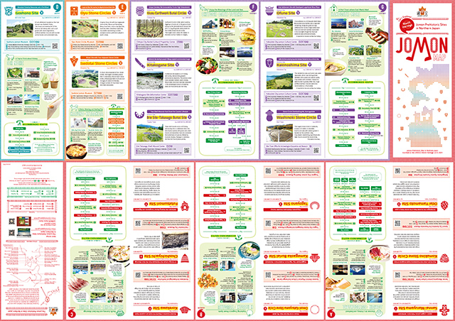
- Outside pages (all areas) (PDF:11.1MB)
- Cover and back cover(PDF:1.30MB)
- Area A (Aomori and Sotogahama) (PDF:1.59MB)
- Area B (Hirosaki and Tsugaru) (PDF:1.69MB)
- Area C (Hachinohe and Shichinohe) (PDF:1.85MB)
- Area D (Ichinohe) and Area E (Kazuno and Kitaakita) (PDF:2.04MB)
- Area F (Chitose, Date and Toyako) (PDF:1.75MB)
- Area G (Hakodate and Mori) (PDF:1.83MB)
Inside pages
These pages include a map of the prehistoric sites as a whole, with information on access from the nearest stations and airports.
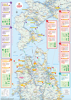
- Inside pages (overall map) (PDF:15.5MB)
- Upper right of the map(PDF:11.4MB)
- Upper left of the map(PDF:9.89MB)
- Lower right of the map(PDF:7.05MB)
- Lower left of the map(PDF:6.82MB)